Boyle Village to Arthur’s Pass
Day 53: Boyle Village to Hope - Kiwi Lodge (27km, of which we walked 17km)
We knew the next section would take us 4 - 5 days and the forecast for day 3 is not looking great. However, rather than wait at Boyle Village for four days we decided to start the next section, prepared to wait out the weather in a hut if need be.
Knowing there was a (probably impassable) river crossing in the very first 10km meant that we all chose the road detour. Fortunately we all had success hitching the 10km (or part thereof) to Windy Point, the official start of the Harpers Pass track.
The walk up to the Halfway Shelter was steep and hot initially but soon flattened out. Here we had lunch before moving on to the Hope - Kiwi Lodge.


Today was a special day. At some point during the day we hit our 1,500km mark. We are now officially half way!

Day 54: Hope -Kiwi Lodge to Hurunui No. 3 hut (30km/approx 8 hours)
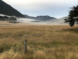
As we left the “lodge” we were greeted by more “big country” - a wide open valley surrounded by mountains.
Today was all relatively flat, albeit crossing a few streams and waterfalls (and more wet flatlands).
We stopped at Hurunui Hut for lunch but decided to push on to No. 3 hut as it was still quite early.
More stream, waterfall and land slip crossings later we made it to No. 3 hut, where we met John and Aimee, two more TA SOBO walkers, who had lit a fire which was lovely to arrive to.


Day 55: No. 3 Hut (0km)
Soon after we arrived yesterday it started to rain. And it rained. And rained. And rained (as forecast).
It rained all through the night. Quite heavy at times. We woke to more rain and decided this would be the day day we sat out in the hut. At one stage Roger ventured outside to have a look at the river and, on coming back told us how cold it was outside. This was further confirmed by the fact it then started snowing on some of the higher peaks. In February!! A bit of a surprise but lovely to see.
The day passed quite quickly with everyone reading, writing, playing cards, drinking lots of tea, spacing out and (limiting snack eating) and even doing some yoga (well Aimee did, anyway). Before we knew it, it was time for bed with fingers and toes crossed that the weather would be fine the next day. The rain had eased slightly so it was looking promising.


Day 56: No. 3 Hut - Locke Stream Hut (via Harpers Pass) (15km / 6 hours)
What a difference a day makes! We woke to a gorgeous sunrise and the promise of a good day ahead.

We set off, all very pleased that we had waited as today we were scheduled to head over Harper’s Pass.
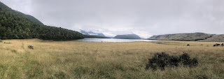
To get there we still had to cross a few streams but nothing major. Very soon we were on our ascent up to the pass. It was a challenging climb - not so much the steepness but the terrain was quite overgrown in places. But then we burst out in to the open and yep, you guessed it, more incredibly views! We were so lucky! The snow on the peaks just added to the amazingness (new word).


We stopped to have lunch at the top of Harpers Pass and enjoy the view. Then it was a steep descent, sometimes walking through water, sometimes not, and then across another massive scree slope, to then reach Locke Stream Hut.

This hut is very interesting for very different reasons. It was built in 1940 with hand-hewn timber by 65-year-old packman, Sam Burrows. The hut was restored in 1993 but has kept a lot of its character.


There was a rumour that there were rats living here but none visited us that night!

Day 57: Locke Stream Hut to Arthur’s Pass Village (42km, of which we walked 20km / approx. 6 hours)
We knew that we had to cross the Taramakau and Otira rivers today so decided to stay together as a group to help each other.

The trail notes advised us to NOT cross where the first trail marker told us to cross and to work our way down one side of the river. We did this and Roger found us a good spot for us all to cross before we ended up bush bashing on a serious level!
Once on the other side we worked our way down alongside the river, trying to work out the best places to cross as we moved down. One more major crossing of the Taramakau which involved some of us linking up and we had made it past that section.
We then had one more crossing ahead of us - the Otira River. Roger has crossed this one in Coast to Coast so had a good idea what it would be like. We all made it across, albeit with Charlie slipping and Aimee losing a pole whilst helping him!
Apart from this minor mishap, we all high-fived once on the other side as this was the end of this section. All we had to do now was walk up to the road at Aitkins Corner and hitch to Arthur’s Pass.


We broke in to smaller groups to hitch then re-met at the Arthur’s Pass Store and Cafe for well-deserved coffee and cake. Whilst there we made plans for dinner at the Wobbly Kea pub (the only pub in town) which was opening at 4pm and closing at 6:30pm!
An early dinner it was then! Still it tasted good.


Comments
Post a Comment